ATLANTA – January 24, 2017 – Just three years after breaking ground, PATH400SM has reached 50 percent completion with 2.5 miles of trail now open to the public. The two newest segments – one between Sidney Marcus Dr. and Miami Circle, the other between Old Ivy Rd. and Wieuca Rd. – officially opened to the public in the waning days of 2016, although nearby residents have been enjoying these sections of the trail since concrete was poured in the late fall.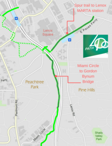
Construction is mobilizing on another one-mile segment of the trail that will run from Miami Circle and across GA 400 to the back of Lenox Square. This is a critical piece of PATH400, as it will provide access to the Lenox MARTA station via a spur trail being built by the Buckhead CID.
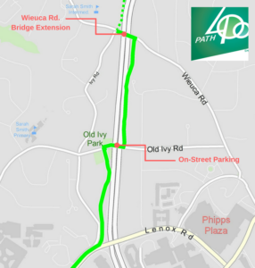
At the northern end of the trail, work has started to extend PATH400 across the Wieuca Rd. bridge over GA 400. This takes PATH400 to the crosswalk used to access Sarah Smith Elementary’s Intermediate Campus, which will make it safer and easier for students to get to school on foot or by bike. Crews will also soon begin work on Old Ivy Rd., creating eight parking spaces under the GA 400 overpass. Not only will this provide parking for PATH400 and the recently added Old Ivy Park, but it will also have a traffic calming effect that will make the area safer for pedestrians.
“We are really picking up steam on this project,” said Denise Starling, executive director of Livable Buckhead. “Each completed segment puts PATH400 within reach of a new set of people — students walking to Sarah Smith Elementary, south Buckhead residents traveling to Miami Circle businesses, and north Buckhead residents looking for a car-free place to exercise. PATH400 now has something to offer all of them.”
 PATH400 is also coming into its own as a vital link in a growing regional network of trails. Sandy Springs is proceeding toward design of the PATH400 segment between Loridans Dr. and I-285, where the greenway is incorporated into the plans for a reconfigured interchange with GA 400. Plans to connect to the South Fork Conservancy’s North Confluence Trail and the Atlanta BeltLine are also proceeding.
Livable Buckhead recently launched a PATH400 website – www.path400greenway.org — to provide construction updates and information about accessing the greenway. In addition to greenway maps and project updates, the site also provides the latest information on events along PATH400.
# # #
About Livable Buckhead
Livable Buckhead is a nonprofit organization that strives to ensure the long-term viability and prosperity of the Buckhead community. The organization achieves its mission by working cooperatively with individuals, public entities and private businesses to integrate sustainable strategies. Livable Buckhead implements programs related to greenspace, recycling, energy efficiency, commute alternatives, arts and culture, real estate development and land use. For more information about Livable Buckhead and its programs, visit livablebuckhead.org.
About PATH400
PATH400 is a 5.2-mile walkable, bikeable greenway being constructed on public land adjacent to GA400 extending from the bank of Peachtree Creek northward toward the northern edge of Atlanta. It is the centerpiece of a broader greenspace plan, the Buckhead Collection, initiated by Atlanta Councilman Howard Shook. Livable Buckhead is spearheading the PATH400 project in partnership with the Buckhead Community Improvement District (Buckhead CID) and the PATH Foundation. Several other agencies and organizations are involved in the development of PATH400, including Georgia Department of Transportation, the City of Atlanta, MARTA, Atlanta Neighborhood Planning Unit B, and Atlanta Public Schools. PATH400 will increase access to community amenities such as arts, historic, and cultural exhibits; neighborhood pocket parks and greenspaces; retail centers; and learning centers. For more information about PATH400 or to donate to the capital campaign, visit livablebuckhead.com.
About PATH Foundation
In just 24 years, PATH has developed over 235 miles of trail throughout Georgia and has become a nationally recognized model for trail-building success. PATH’s linear parks have become part of the landscape in urban and rural areas, in affluent and impoverished communities. PATH trails are bringing people together from all races, ages, income levels and cultural backgrounds. Significant progress toward building Atlanta a network of trails includes: The Silver Comet, Stone Mountain, Lionel Hampton, Westside, Arabia Mountain, Chastain Park, South Decatur Trolley, Northwest Atlanta, and Freedom Park Trails.